Transportation And Infrastructure, Residential And Commercial Development Surveys, Computation And CAD Mapping, Housing Development, Three Dimensional Laser Scanning, Software Development, Engineering Surveying, COR Certified, Geomatics Engineering Surveys, Oil And Gas, Mining & Tunneling, Professional Land Surveyors & Geomatics Engineers, Land Development, Geodetic Surveying, Cadastral Surveying, First Nations Development Surveys, Construction Surveying
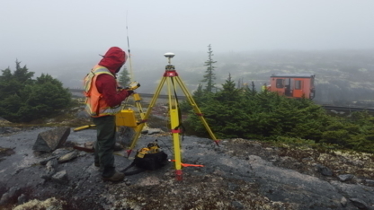
Professional Land Surveyors and Geomatics Engineers serving Northern Canada since 1960, with a full range of services including Cadastral, Engineering and Geodetic surveys, Mapping and GIS services.more...See more text
Transportation And Infrastructure, Residential And Commercial Development Surveys, Computation And CAD Mapping, Housing Development, Three Dimensional Laser Scanning, Software Development, Engineering Surveying, COR Certified, Geomatics Engineering Surveys, Oil And Gas, Mining & Tunneling, Professional Land Surveyors & Geomatics Engineers, Land Development, Geodetic Surveying, Cadastral Surveying, First Nations Development Surveys, Construction Surveying
Underhill Geomatics Ltd. (UGL) was established in Vancouver in 1913 and has operated continuously since then, providing comprehensive geomatics expertise to industry, government an...more...See more text